|
|
| |
|
|
| |
|
|
|
|
| |
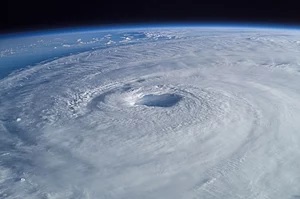 |
| Hurricane Isabel
(2003) as seen from orbit during Expedition 7 of
the International Space Station. The eye,
eyewall, and surrounding rainbands,
characteristics of tropical cyclones in the
narrow sense, are clearly visible in this view
from space. |
Tropical Cyclones
A tropical cyclone is a rapidly rotating storm system
characterized by a low-pressure center, a closed
low-level atmospheric circulation, strong winds, and a
spiral arrangement of thunderstorms that produce heavy
rain and/or squalls. Depending on its location and
strength, a tropical cyclone is referred to by different
names, including hurricane (/ˈhʌrɪkən, -keɪn/), typhoon
(/taɪˈfuːn/), tropical storm, cyclonic storm, tropical
depression, or simply cyclone. A hurricane is a tropical
cyclone that occurs in the Atlantic Ocean and
northeastern Pacific Ocean, and a typhoon occurs in the
northwestern Pacific Ocean; in the south Pacific or
Indian Ocean, comparable storms are referred to simply
as "tropical cyclones" or "severe cyclonic storms".
"Tropical" refers to the geographical origin of these
systems, which form almost exclusively over tropical
seas. "Cyclone" refers to their winds moving in a
circle, whirling round their central clear eye, with
their winds blowing counterclockwise in the Northern
Hemisphere and clockwise in the Southern Hemisphere. The
opposite direction of circulation is due to the Coriolis
effect. Tropical cyclones typically form over large
bodies of relatively warm water. They derive their
energy through the evaporation of water from the ocean
surface, which ultimately recondenses into clouds and
rain when moist air rises and cools to saturation. This
energy source differs from that of mid-latitude cyclonic
storms, such as nor'easters and European windstorms,
which are fueled primarily by horizontal temperature
contrasts. Tropical cyclones are typically between 100
and 2,000 km (62 and 1,243 mi) in diameter.
The strong rotating winds of a tropical cyclone are a
result of the conservation of angular momentum imparted
by the Earth's rotation as air flows inwards toward the
axis of rotation. As a result, they rarely form within
5° of the equator. Tropical cyclones are almost unknown
in the South Atlantic due to a consistently strong wind
shear and a weak Intertropical Convergence Zone.
Conversely, the African easterly jet and areas of
atmospheric instability give rise to cyclones in the
Atlantic Ocean and Caribbean Sea, while cyclones near
Australia owe their genesis to the Asian monsoon and
Western Pacific Warm Pool.
The primary energy source for these storms is warm ocean
waters. These storms are therefore typically strongest
when over or near water, and weaken quite rapidly over
land. This causes coastal regions to be particularly
vulnerable to tropical cyclones, compared to inland
regions. Coastal damage may be caused by strong winds
and rain, high waves (due to winds), storm surges (due
to wind and severe pressure changes), and the potential
of spawning tornadoes. Tropical cyclones draw in air
from a large area and concentrate the water content of
that air (from atmospheric moisture and moisture
evaporated from water) into precipitation over a much
smaller area. This replenishing of moisture-bearing air
after rain may cause multi-hour or multi-day extremely
heavy rain up to 40 kilometers (25 mi) from the
coastline, far beyond the amount of water that the local
atmosphere holds at any one time. This in turn can lead
to river flooding, overland flooding, and a general
overwhelming of local water control structures across a
large area. Although their effects on human populations
can be devastating, tropical cyclones can relieve
drought conditions. They also carry heat and energy away
from the tropics and transport it towards temperate
latitudes, which could play an important role in
regulating global climate. |
|
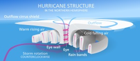 |
| Diagram of a
Northern hemisphere hurricane. |
Physical
structure
A tropical cyclone is the generic term for a warm-cored,
non-frontal synoptic-scale low-pressure system over
tropical or subtropical waters around the world. The
systems generally have a well-defined center which is
surrounded by deep atmospheric convection and a closed
wind circulation at the surface. Historically tropical
cyclones have occurred around the world for thousands of
years, with one of the earliest tropical cyclones on
record estimated to have occurred in around 6000 B.C.
However, before satellite imagery, became available
during the 20th century, many of these systems went
undetected unless it impacted land or a ship encountered
it by chance. These days, on average around 80 to 90
named tropical cyclones form each year around the world,
of which over half of which develop hurricane-force
winds of 65 kn (120 km/h; 75 mph) or more.
Tropical cyclones on either side of the Equator have
their origins in the Intertropical Convergence Zone,
where winds blow from either the northeast or southeast.
Within this broad area of low-pressure air is heated
over the warm tropical ocean and rises in discrete
parcels which causes thundery showers to form. These
showers dissipate quite quickly, however, they can group
together into large clusters of thunderstorms. This
creates a flow of warm, moist, rapidly rising air, which
starts to rotate cyclonically as it interacts with the
rotation of the earth and leads to the development of a
depression.
Wind field
The near-surface wind field of a tropical cyclone is
characterized by air rotating rapidly around a center of
circulation while also flowing radially inwards. At the
outer edge of the storm, air may be nearly calm;
however, due to the Earth's rotation, the air has
non-zero absolute angular momentum. As air flows
radially inward, it begins to rotate cyclonically
(counter-clockwise in the Northern Hemisphere, and
clockwise in the Southern Hemisphere) to conserve
angular momentum. At an inner radius, air begins to
ascend to the top of the troposphere. This radius is
typically coincident with the inner radius of the
eyewall, and has the strongest near-surface winds of the
storm; consequently, it is known as the radius of
maximum winds. Once aloft, air flows away from the
storm's center, producing a shield of cirrus clouds.
The previously mentioned processes result in a nearly
axisymmetric wind field: Wind speeds are low at the
center, increase rapidly moving outwards to the radius
of maximum winds, and then decay more gradually with
radius to large radii. However, the wind field often
exhibits additional spatial and temporal variability due
to the effects of localized processes, such as
thunderstorm activity and horizontal flow instabilities.
In the vertical direction, winds are strongest near the
surface and decay with height within the troposphere. |
 |
| Thunderstorm
activity in the eyewall of Cyclone Bansi as seen
from the International Space Station, on January
12, 2015. |
Eye and center
At the center of a mature tropical cyclone, air sinks
rather than rises. For a sufficiently strong storm, air
may sink over a layer deep enough to suppress cloud
formation, thereby creating a clear "eye". Weather in
the eye is normally calm and free of convective clouds,
although the sea may be extremely violent. The eye is
normally circular and is typically 30–65 km (19–40 mi)
in diameter, though eyes as small as 3 km (1.9 mi) and
as large as 370 km (230 mi) have been observed.
The cloudy outer edge of the eye is called the "eyewall".
The eyewall typically expands outward with height,
resembling an arena football stadium; this phenomenon is
sometimes referred to as the "stadium effect". The
eyewall is where the greatest wind speeds are found, air
rises most rapidly, clouds reach their highest altitude,
and precipitation is the heaviest. The heaviest wind
damage occurs where a tropical cyclone's eyewall passes
over land.
In a weaker storm, the eye may be obscured by the
central dense overcast, which is the upper-level cirrus
shield that is associated with a concentrated area of
strong thunderstorm activity near the center of a
tropical cyclone.
The eyewall may vary over time in the form of eyewall
replacement cycles, particularly in intense tropical
cyclones. Outer rainbands can organize into an outer
ring of thunderstorms that slowly moves inward, which is
believed to rob the primary eyewall of moisture and
angular momentum. When the primary eyewall weakens, the
tropical cyclone weakens temporarily. The outer eyewall
eventually replaces the primary one at the end of the
cycle, at which time the storm may return to its
original intensity. |
|
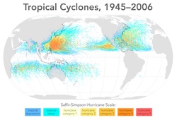 |
| Map of all tropical
cyclone tracks from 1945 to 2006. Equal-area
projection. |
Formation
Worldwide, tropical cyclone activity peaks in late
summer, when the difference between temperatures aloft
and sea surface temperatures is the greatest. However,
each particular basin has its own seasonal patterns. On
a worldwide scale, May is the least active month, while
September is the most active month. November is the only
month in which all the tropical cyclone basins are in
season.
Factors
The formation of tropical cyclones is the topic of
extensive ongoing research and is still not fully
understood.[20][needs update] While six factors appear
to be generally necessary, tropical cyclones may
occasionally form without meeting all of the following
conditions. In most situations, water temperatures of at
least 26.5 °C (79.7 °F) are needed down to a depth of at
least 50 m (160 ft); waters of this temperature cause
the overlying atmosphere to be unstable enough to
sustain convection and thunderstorms. For tropical
transitioning cyclones (i.e. Hurricane Ophelia (2017)) a
water temperature of at least 22.5 °C (72.5 °F) has been
suggested.
Another factor is rapid cooling with height, which
allows the release of the heat of condensation that
powers a tropical cyclone. High humidity is needed,
especially in the lower-to-mid troposphere; when there
is a great deal of moisture in the atmosphere,
conditions are more favorable for disturbances to
develop. Low amounts of wind shear are needed, as high
shear is disruptive to the storm's circulation. Tropical
cyclones generally need to form more than 555 km (345
mi) or five degrees of latitude away from the equator,
allowing the Coriolis effect to deflect winds blowing
towards the low pressure center and creating a
circulation. Lastly, a formative tropical cyclone needs
a preexisting system of disturbed weather. Tropical
cyclones will not form spontaneously. Low-latitude and
low-level westerly wind bursts associated with the
Madden–Julian oscillation can create favorable
conditions for tropical cyclogenesis by initiating
tropical disturbances.
Locations
Most tropical cyclones form in a worldwide band of
thunderstorm activity near the equator, referred to as
the Intertropical Front (ITF), the Intertropical
Convergence Zone (ITCZ), or the monsoon trough. Another
important source of atmospheric instability is found in
tropical waves, which contribute to the development of
about 85% of intense tropical cyclones in the Atlantic
Ocean and become most of the tropical cyclones in the
Eastern Pacific. The majority forms between 10 and 30
degrees of latitude away of the equator, and 87% forms
no farther away than 20 degrees north or south. Because
the Coriolis effect initiates and maintains their
rotation, tropical cyclones rarely form or move within 5
degrees of the equator, where the effect is weakest.
However, it is still possible for tropical systems to
form within this boundary as Tropical Storm Vamei and
Cyclone Agni did in 2001 and 2004, respectively. |
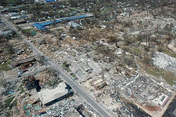 |
| The aftermath of
Hurricane Katrina in Gulfport, Mississippi. |
Effects
Tropical cyclones out at sea cause large waves, heavy
rain, flood and high winds, disrupting international
shipping and, at times, causing shipwrecks. Tropical
cyclones stir up water, leaving a cool wake behind them,
which causes the region to be less favorable for
subsequent tropical cyclones. On land, strong winds can
damage or destroy vehicles, buildings, bridges, and
other outside objects, turning loose debris into deadly
flying projectiles. The storm surge, or the increase in
sea level due to the cyclone, is typically the worst
effect from landfalling tropical cyclones, historically
resulting in 90% of tropical cyclone deaths. The broad
rotation of a landfalling tropical cyclone, and vertical
wind shear at its periphery, spawns tornadoes. Tornadoes
can also be spawned as a result of eyewall mesovortices,
which persist until landfall.
Over the past two centuries, tropical cyclones have been
responsible for the deaths of about 1.9 million people
worldwide. Large areas of standing water caused by
flooding lead to infection, as well as contributing to
mosquito-borne illnesses. Crowded evacuees in shelters
increase the risk of disease propagation. Tropical
cyclones significantly interrupt infrastructure, leading
to power outages, bridge destruction, and the hampering
of reconstruction efforts. On average, the Gulf and east
coasts of the United States suffer approximately US$5
billion (1995 US $) in cyclone damage every year. The
majority (83%) of tropical cyclone damage is caused by
severe hurricanes, category 3 or greater. However,
category 3 or greater hurricanes only account for about
one-fifth of cyclones that make landfall every year.
Although cyclones take an enormous toll in lives and
personal property, they may be important factors in the
precipitation regimes of places they impact, as they may
bring much-needed precipitation to otherwise dry
regions. Tropical cyclones also help maintain the global
heat balance by moving warm, moist tropical air to the
middle latitudes and polar regions, and by regulating
the thermohaline circulation through upwelling. The
storm surge and winds of hurricanes may be destructive
to human-made structures, but they also stir up the
waters of coastal estuaries, which are typically
important fish breeding locales. Tropical cyclone
destruction spurs redevelopment, greatly increasing
local property values.
When hurricanes surge upon shore from the ocean, salt is
introduced to many freshwater areas and raises the
salinity levels too high for some habitats to withstand.
Some are able to cope with the salt and recycle it back
into the ocean, but others can not release the extra
surface water quickly enough or do not have a large
enough freshwater source to replace it. Because of this,
some species of plants and vegetation die due to the
excess salt. In addition, hurricanes can carry toxins
and acids onto shore when they make landfall. The flood
water can pick up the toxins from different spills and
contaminate the land that it passes over. The toxins are
very harmful to the people and animals in the area, as
well as the environment around them. The flooding water
can also spark many dangerous oil spills. |
|
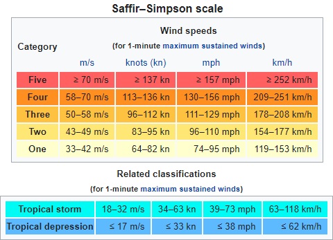
Classifications,
terminology, and naming
Nomenclature and intensity
classifications
Around the world, tropical cyclones are classified in
different ways, based on the location, the structure of
the system and its intensity. For example, within the
Northern Atlantic and Eastern Pacific basins, a tropical
cyclone with wind speeds of over 65 kn (75 mph; 120
km/h) is called a hurricane, while it is called a
typhoon or a severe cyclonic storm within the Western
Pacific or North Indian Oceans. Within the Southern
Hemisphere, it is either called a hurricane, tropical
cyclone or a severe tropical cyclone, depending on if it
is located within the South Atlantic, South-West Indian
Ocean, Australian region or the South Pacific Ocean.
Naming
The practice of using names to identify tropical
cyclones goes back many years, with systems named after
places or things they hit before the formal start of
naming. The system currently used provides positive
identification of severe weather systems in a brief
form, that is readily understood and recognized by the
public. The credit for the first usage of personal names
for weather systems is generally given to the Queensland
Government Meteorologist Clement Wragge who named
systems between 1887 and 1907. This system of naming
weather systems subsequently fell into disuse for
several years after Wragge retired, until it was revived
in the latter part of World War II for the Western
Pacific. Formal naming schemes have subsequently been
introduced for the North and South Atlantic, Eastern,
Central, Western and Southern Pacific basins as well as
the Australian region and Indian Ocean.
At present, tropical cyclones are officially named by
one of twelve meteorological services and retain their
names throughout their lifetimes to provide ease of
communication between forecasters and the general public
regarding forecasts, watches, and warnings. Since the
systems can last a week or longer and more than one can
be occurring in the same basin at the same time, the
names are thought to reduce the confusion about what
storm is being described. Names are assigned in order
from predetermined lists with one, three, or ten-minute
sustained wind speeds of more than 65 km/h (40 mph)
depending on which basin it originates.However,
standards vary from basin to basin with some tropical
depressions named in the Western Pacific, while tropical
cyclones have to have a significant amount of gale-force
winds occurring around the center before they are named
within the Southern Hemisphere. The names of significant
tropical cyclones in the North Atlantic Ocean, Pacific
Ocean, and Australian region are retired from the naming
lists and replaced with another name. |
|
|
|
|
|
|
|
|
|
|
|
|
|
|
|
|
|
|
Search Fun Easy English |
|
|
|
|
|
|
|
|
|
|
|
|
|
|
|
About
Contact
Copyright
Resources
Site Map |