|
|
| |
|
|
| |
|
|
|
|
| |
 |
| A view of Earth's
troposphere from an airplane. |
Troposphere
The troposphere is the lowest layer of Earth's
atmosphere, and is also where nearly all weather
conditions take place. It contains 75% of the
atmosphere's mass and 99% of the total mass is water
vapour and aerosols. The average height of the
troposphere is 18 km (11 mi; 59,000 ft) in the tropics,
17 km (11 mi; 56,000 ft) in the middle latitudes, and 6
km (3.7 mi; 20,000 ft) in the polar regions in winter.
The total average height of the troposphere is 13 km
(8.1 mi; 43,000 ft).
The lowest part of the troposphere, where friction with
the Earth's surface influences airflow, is the planetary
boundary layer. This layer is typically a few hundred
meters to 2 km (1.2 mi; 6,600 ft) deep depending on the
landform and time of day. Atop the troposphere is the
tropopause, which is the border between the troposphere
and stratosphere. The tropopause is an inversion layer,
where the air temperature ceases to decrease with height
and remains constant through its thickness.
The word troposphere is derived from the Greek tropos
(meaning "turn, turn toward, change") and sphere (as in
the Earth), reflecting the fact that rotational
turbulent mixing plays an important role in the
troposphere's structure and behaviour. Most of the
phenomena associated with day-to-day weather occur in
the troposphere. |
|
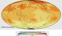 |
| This image shows the
temperature trend in the Middle Troposphere as
measured by a series of satellite-based
instruments between January 1979 and December
2005. The middle troposphere is centered around
5 kilometers above the surface. Oranges and
yellows dominate the troposphere image,
indicating that the air nearest the Earth's
surface warmed during the period."Source". |
Pressure and
temperature structure
Composition
By volume, dry air contains 78.08% nitrogen, 20.95%
oxygen, 0.93% argon, 0.04% carbon dioxide, and small
amounts of other gases. Air also contains a variable
amount of water vapor. Except for the water vapor
content, the composition of the troposphere is
essentially uniform.[citation needed] The source of
water vapor is at the Earth's surface through the
process of evaporation. The temperature of the
troposphere decreases with altitude. And, saturation
vapor pressure decreases strongly as temperature drops.
Hence, the amount of water vapor that can exist in the
atmosphere decreases strongly with altitude and the
proportion of water vapor is normally greatest near the
surface of the Earth.
Pressure
The pressure of the atmosphere is maximum at sea level
and decreases with altitude. This is because the
atmosphere is very nearly in hydrostatic equilibrium so
that the pressure is equal to the weight of air above a
given point.
Temperature
This image shows the temperature trend in the Middle
Troposphere as measured by a series of satellite-based
instruments between January 1979 and December 2005. The
middle troposphere is centered around 5 kilometers above
the surface. Oranges and yellows dominate the
troposphere image, indicating that the air nearest the
Earth's surface warmed during the period."Source".
The temperature of the troposphere generally decreases
as altitude increases. The rate at which the temperature
decreases, dT/dz, is called the environmental lapse rate
(ELR). The ELR is nothing more than the difference in
temperature between the surface and the tropopause
divided by the height. The ELR assumes that the air is
perfectly still, i.e. that there is no mixing of the
layers of air from vertical convection, nor winds that
would create turbulence and hence mixing of the layers
of air. The reason for this temperature difference is
that the ground absorbs most of the sun's energy, which
then heats the lower levels of the atmosphere with which
it is in contact. Meanwhile, the radiation of heat at
the top of the atmosphere results in the cooling of that
part of the atmosphere. |
|
Tropopause
The tropopause is the boundary region between the
troposphere and the stratosphere.
Measuring the temperature change with height through the
troposphere and the stratosphere identifies the location
of the tropopause. In the troposphere, temperature
decreases with altitude. In the stratosphere, however,
the temperature remains constant for a while and then
increases with altitude. This coldest layer of the
atmosphere, where the lapse rate changes from positive
(in the troposphere) to negative (in the stratosphere),
is defined as the tropopause. Thus, the tropopause is an
inversion layer, and there is little mixing between the
two layers of the atmosphere. |
|
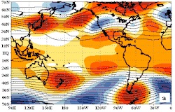 |
| A zonal flow regime.
Note the dominant west-to-east flow as shown in
the 500 hPa height pattern. |
Atmospheric flow
The flow of the atmosphere generally moves in a west to east
direction. This, however, can often become interrupted,
creating a more north to south or south to north flow. These
scenarios are often described in meteorology as zonal or
meridional. These terms, however, tend to be used about
localized areas of the atmosphere (at a synoptic scale). A
fuller explanation of the flow of atmosphere around the
Earth as a whole can be found in the three-cell model.
Zonal flow
A zonal flow regime is the meteorological term meaning that
the general flow pattern is west to east along the Earth's
latitude lines, with weak shortwaves embedded in the flow.
The use of the word "zone" refers to the flow being along
the Earth's latitudinal "zones". This pattern can buckle and
thus become a meridional flow.
Meridional flow
When the zonal flow buckles, the atmosphere can flow in a
more longitudinal (or meridional) direction, and thus the
term "meridional flow" arises. Meridional flow patterns
feature strong, amplified troughs of low pressure and ridges
of high pressure, with more north–south flow in the general
pattern than west-to-east flow.
Three-cell model
The three-cell model of the atmosphere attempts to describe
the actual flow of the Earth's atmosphere as a whole. It
divides the Earth into the tropical (Hadley cell),
mid-latitude (Ferrel cell), and polar (polar cell) regions,
to describe energy flow and global atmospheric circulation
(mass flow). Its fundamental principle is that of balance –
the energy that the Earth absorbs from the sun each year is
equal to that which it loses to space by radiation. This
overall Earth energy balance, however, does not apply in
each latitude due to the varying strength of the sun in each
"cell" as a result of the tilt of the Earth's axis
concerning its orbit. The result is a circulation of the
atmosphere that transports warm air poleward from the
tropics and cold air equatorward from the poles. The effect
of the three cells is the tendency to even out the heat and
moisture in the Earth's atmosphere around the planet. |
|
|
|
|
|
|
|
|
|
|
|
|
|
|
|
|
|
|
Search Fun Easy English |
|
|
|
|
|
|
|
|
|
|
|
|
|
|
|
About
Contact
Copyright
Resources
Site Map |