|
|
| |
|
|
| |
|
|
|
|
| |
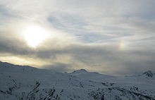 |
| Parhelion (sundog)
in Savoie. |
Meteorology
Meteorology is a branch of the atmospheric sciences
which includes atmospheric chemistry and atmospheric
physics, with a major focus on weather forecasting. The
study of meteorology dates back millennia, though
significant progress in meteorology did not occur until
the 18th century. The 19th century saw modest progress
in the field after weather observation networks were
formed across broad regions. Prior attempts at
prediction of weather depended on historical data. It
was not until after the elucidation of the laws of
physics and more particularly, the development of the
computer, allowing for the automated solution of a great
many equations that model the weather, in the latter
half of the 20th century that significant breakthroughs
in weather forecasting were achieved. An important
domain of weather forecasting is marine weather
forecasting as it relates to maritime and coastal
safety, in which weather effects also include
atmospheric interactions with large bodies of water.
Meteorological phenomena are observable weather events
that are explained by the science of meteorology.
Meteorological phenomena are described and quantified by
the variables of Earth's atmosphere: temperature, air
pressure, water vapour, mass flow, and the variations
and interactions of those variables, and how they change
over time. Different spatial scales are used to describe
and predict weather on local, regional, and global
levels.
Meteorology, climatology, atmospheric physics, and
atmospheric chemistry are sub-disciplines of the
atmospheric sciences. Meteorology and hydrology compose
the interdisciplinary field of hydrometeorology. The
interactions between Earth's atmosphere and its oceans
are part of a coupled ocean-atmosphere system.
Meteorology has application in many diverse fields such
as the military, energy production, transport,
agriculture, and construction.
The word meteorology is from the Ancient Greek μετέωρος
metéōros (meteor) and -λογία -logia (-(o)logy), meaning
"the study of things high in the air." |
|
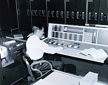 |
| A meteorologist at
the console of the IBM 7090 in the Joint
Numerical Weather Prediction Unit. c. 1965. |
Meteorologists
Meteorologists are scientists who study and work in the
field of meteorology. The American Meteorological Society
publishes and continually updates an authoritative
electronic Meteorology Glossary. Meteorologists work in
government agencies, private consulting and research
services, industrial enterprises, utilities, radio and
television stations, and in education. In the United States,
meteorologists held about 10,000 jobs in 2018.
Although weather forecasts and warnings are the best known
products of meteorologists for the public, weather
presenters on radio and television are not necessarily
professional meteorologists. They are most often reporters
with little formal meteorological training, using
unregulated titles such as weather specialist or weatherman.
The American Meteorological Society and National Weather
Association issue "Seals of Approval" to weather
broadcasters who meet certain requirements but this is not
mandatory to be hired by the medias. |
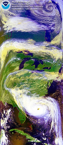 |
| Satellite image of
Hurricane Hugo with a polar low visible at the
top of the image. |
History
The ability to predict rains and floods based on annual
cycles was evidently used by humans at least from the time
of agricultural settlement if not earlier. Early approaches
to predicting weather were based on astrology and were
practiced by priests. Cuneiform inscriptions on Babylonian
tablets included associations between thunder and rain. The
Chaldeans differentiated the 22° and 46° halos.
Ancient Indian Upanishads contain mentions of clouds and
seasons. The Samaveda mentions sacrifices to be performed
when certain phenomena were noticed. Varāhamihira's
classical work Brihatsamhita, written about 500 AD, provides
evidence of weather observation.
In 350 BC, Aristotle wrote Meteorology. Aristotle is
considered the founder of meteorology. One of the most
impressive achievements described in the Meteorology is the
description of what is now known as the hydrologic cycle.
The book De Mundo (composed before 250 BC or between 350 and
200 BC) noted:
If the flashing body is set on fire and rushes violently to
the Earth it is called a thunderbolt; if it is only half of
fire, but violent also and massive, it is called a meteor;
if it is entirely free from fire, it is called a smoking
bolt. They are all called 'swooping bolts' because they
swoop down upon the Earth. Lightning is sometimes smoky, and
is then called 'smoldering lightning"; sometimes it darts
quickly along, and is then said to be vivid. At other times,
it travels in crooked lines, and is called forked lightning.
When it swoops down upon some object it is called 'swooping
lightning'.
The Greek scientist Theophrastus compiled a book on weather
forecasting, called the Book of Signs. The work of
Theophrastus remained a dominant influence in the study of
weather and in weather forecasting for nearly 2,000 years.
In 25 AD, Pomponius Mela, a geographer for the Roman Empire,
formalized the climatic zone system. According to Toufic
Fahd, around the 9th century, Al-Dinawari wrote the Kitab
al-Nabat (Book of Plants), in which he deals with the
application of meteorology to agriculture during the Arab
Agricultural Revolution. He describes the meteorological
character of the sky, the planets and constellations, the
sun and moon, the lunar phases indicating seasons and rain,
the anwa (heavenly bodies of rain), and atmospheric
phenomena such as winds, thunder, lightning, snow, floods,
valleys, rivers, lakes.
Early attempts at predicting weather were often related to
prophecy and divining, and were sometimes based on
astrological ideas. Admiral FitzRoy tried to separate
scientific approaches from prophetic ones.
The arrival of the electrical telegraph in 1837
afforded, for the first time, a practical method for
quickly gathering surface weather observations from a
wide area. This data could be used to produce maps of
the state of the atmosphere for a region near the
Earth's surface and to study how these states evolved
through time.
To make frequent weather forecasts based on this data
required a reliable network of observations, but it was
not until 1849 that the Smithsonian Institution began to
establish an observation network across the United
States under the leadership of Joseph Henry . Similar
observation networks were established in Europe at this
time.
In 1854, the United Kingdom government appointed Robert
FitzRoy to the new office of Meteorological Statist to
the Board of Trade with the role of gathering weather
observations at sea. FitzRoy's office became the United
Kingdom Meteorological Office in 1854, the first
national meteorological service in the world. The first
daily weather forecasts made by FitzRoy's Office were
published in The Times newspaper in 1860. The following
year a system was introduced of hoisting storm warning
cones at principal ports when a gale was expected.
Over the next 50 years many countries established
national meteorological services: Finnish Meteorological
Central Office (1881) was formed from part of Magnetic
Observatory of Helsinki University; India Meteorological
Department (1889) established following tropical cyclone
and monsoon related famines in the previous decades;
United States Weather Bureau (1890) was established
under the United States Department of Agriculture;
Australian Bureau of Meteorology (1905) established by a
Meteorology Act to unify existing state meteorological
services. |
|
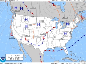 |
| NOAA: Synoptic scale
weather analysis. |
Sub-classifications
In the study of the atmosphere, meteorology can be
divided into distinct areas.
Boundary layer meteorology
Boundary layer meteorology is the study of processes in
the air layer directly above Earth's surface, known as
the atmospheric boundary layer (ABL) or peplosphere. The
effects of the surface – heating, cooling, and friction
– cause turbulent mixing within the air layer.
Significant fluxes of heat, matter, or momentum on time
scales of less than a day are advected by turbulent
motions. Boundary layer meteorology includes the study
of all types of surface-atmosphere boundary, including
ocean, lake, urban land and non-urban land.
Mesoscale meteorology
Mesoscale meteorology is the study of atmospheric
phenomena that has horizontal scales ranging from
microscale limits to synoptic scale limits and a
vertical scale that starts at the Earth's surface and
includes the atmospheric boundary layer, troposphere,
tropopause, and the lower section of the stratosphere.
Mesoscale timescales last from less than a day to the
lifetime of the event, which in some cases can be weeks.
The events typically of interest are thunderstorms,
squall lines, fronts, precipitation bands in tropical
and extratropical cyclones, and topographically
generated weather systems such as mountain waves and sea
and land breezes.
Synoptic scale
Synoptic scale meteorology is generally large area
dynamics referred to in horizontal coordinates and with
respect to time. The phenomena typically described by
synoptic meteorology include events like extratropical
cyclones, baroclinic troughs and ridges, frontal zones,
and to some extent jets. All of these are typically
given on weather maps for a specific time. The minimum
horizontal scale of synoptic phenomena are limited to
the spacing between surface observation stations. |
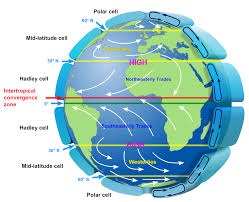 |
| General circulation
of the Earth's atmosphere: The westerlies and
trade winds are part of the Earth's atmospheric
circulation. |
Global scale
Global scale meteorology is study of weather patterns
related to the transport of heat from the tropics to the
poles. Also, very large scale oscillations are of
importance. Those oscillations have time periods
typically longer than a full annual seasonal cycle, such
as ENSO, PDO, MJO, etc. Global scale pushes the
thresholds of the perception of meteorology into
climatology. The traditional definition of climate is
pushed in to larger timescales with the further
understanding of how the global oscillations cause both
climate and weather disturbances in the synoptic and
mesoscale timescales.
Numerical Weather Prediction is a main focus in
understanding air-sea interaction, tropical meteorology,
atmospheric predictability, and tropospheric/stratospheric
processes.
Dynamic meteorology
Dynamic meteorology generally focuses on the physics of
the atmosphere. The idea of air parcel is used to define
the smallest element of the atmosphere, while ignoring
the discrete molecular and chemical nature of the
atmosphere. An air parcel is defined as a point in the
fluid continuum of the atmosphere. The fundamental laws
of fluid dynamics, thermodynamics, and motion are used
to study the atmosphere. The physical quantities that
characterize the state of the atmosphere are
temperature, density, pressure, etc. These variables
have unique values in the continuum.
Aviation meteorology
Aviation meteorology deals with the impact of weather on
air traffic management. It is important for air crews to
understand the implications of weather on their flight
plan as well as their aircraft, as noted by the
Aeronautical Information Manual:
The effects of ice on aircraft are cumulative-thrust is
reduced, drag increases, lift lessens, and weight
increases. The results are a decrease in stall speed and
a deterioration of aircraft performance. In extreme
cases, 2 to 3 inches of ice can form on the leading edge
of the airfoil in less than 5 minutes. It takes but 1/2
inch of ice to reduce the lifting power of some aircraft
by 50 percent and increases the frictional drag by an
equal percentage.
Agricultural meteorology
Meteorologists, soil scientists, agricultural
hydrologists, and agronomists are persons concerned with
studying the effects of weather and climate on plant
distribution, crop yield, water-use efficiency,
phenology of plant and animal development, and the
energy balance of managed and natural ecosystems.
Conversely, they are interested in the role of
vegetation on climate and weather.
Hydrometeorology
Hydrometeorology is the branch of meteorology that deals
with the hydrologic cycle, the water budget, and the
rainfall statistics of storms. A hydrometeorologist
prepares and issues forecasts of accumulating
(quantitative) precipitation, heavy rain, heavy snow,
and highlights areas with the potential for flash
flooding. Typically the range of knowledge that is
required overlaps with climatology, mesoscale and
synoptic meteorology, and other geosciences. |
|
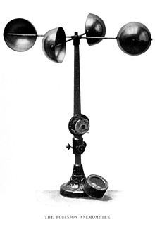 |
| A hemispherical cup
anemometer. |
Equipment
Generally speaking, each science has its own unique sets
of laboratory equipment. However, meteorology is a
science which does not use much lab equipment but relies
more on field-mode observation equipment.
In science, an observation, or observable, is an
abstract idea that can be measured and data can be
taken. In the atmosphere, there are many things or
qualities of the atmosphere that can be measured. Rain,
which can be observed, or seen anywhere and anytime was
one of the first ones to be measured historically. Also,
two other accurately measured qualities are wind and
humidity. Neither of these can be seen but can be felt.
The devices to measure these three sprang up in the
mid-15th century and were respectively the rain gauge,
the anemometer, and the hygrometer.
Sets of surface measurements are important data to
meteorologists. They give a snapshot of a variety of
weather conditions at one single location and are
usually at a weather station, a ship or a weather buoy.
The measurements taken at a weather station can include
any number of atmospheric observables. Usually,
temperature, pressure, wind measurements, and humidity
are the variables that are measured by a thermometer,
barometer, anemometer, and hygrometer, respectively.
Upper air data are of crucial importance for weather
forecasting. The most widely used technique is launches
of radiosondes. Supplementing the radiosondes a network
of aircraft collection is organized by the World
Meteorological Organization.
Remote sensing, as used in meteorology, is the concept
of collecting data from remote weather events and
subsequently producing weather information. The common
types of remote sensing are Radar, Lidar, and satellites
(or photogrammetry). Each collects data about the
atmosphere from a remote location and, usually, stores
the data where the instrument is located. RADAR and
LIDAR are not passive because both use EM radiation to
illuminate a specific portion of the atmosphere.
The 1960 launch of the first successful weather
satellite, TIROS-1, marked the beginning of the age
where weather information became available globally.
Weather satellites along with more general-purpose
Earth-observing satellites circling the earth at various
altitudes have become an indispensable tool for studying
a wide range of phenomena from forest fires to El Niño.
In recent years, climate models have been developed that
feature a resolution comparable to older weather
prediction models. These climate models are used to
investigate long-term climate shifts, such as what
effects might be caused by human emission of greenhouse
gases.
Weather forecasting
Weather forecasting is the application of science and
technology to predict the state of the atmosphere for a
future time and a given location. Human beings have
attempted to predict the weather informally for
millennia, and formally since at least the nineteenth
century. Weather forecasts are made by collecting
quantitative data about the current state of the
atmosphere and using scientific understanding of
atmospheric processes to project how the atmosphere will
evolve.
Once an all human endeavor based mainly upon changes in
barometric pressure, current weather conditions, and sky
condition, forecast models are now used to determine
future conditions. Human input is still required to pick
the best possible forecast model to base the forecast
upon, which involves pattern recognition skills,
teleconnections, knowledge of model performance, and
knowledge of model biases. The chaotic nature of the
atmosphere, the massive computational power required to
solve the equations that describe the atmosphere, error
involved in measuring the initial conditions, and an
incomplete understanding of atmospheric processes mean
that forecasts become less accurate as the difference in
current time and the time for which the forecast is
being made (the range of the forecast) increases. The
use of ensembles and model consensus help narrow the
error and pick the most likely outcome.
There are a variety of end users to weather forecasts.
Weather warnings are important forecasts because they
are used to protect life and property. Forecasts based
on temperature and precipitation are important to
agriculture, and therefore to commodity traders within
stock markets. Temperature forecasts are used by utility
companies to estimate demand over coming days. On an
everyday basis, people use weather forecasts to
determine what to wear on a given day. Since outdoor
activities are severely curtailed by heavy rain, snow
and the wind chill, forecasts can be used to plan
activities around these events, and to plan ahead and
survive them. |
|
|
|
|
|
|
|
|
|
|
|
|
|
|
|
|
|
|
Search Fun Easy English |
|
|
|
|
|
|
|
|
|
|
|
|
|
|
|
About
Contact
Copyright
Resources
Site Map |