|
|
| |
|
|
| |
|
|
|
|
| |
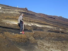 |
| Volcanologist
examining tephra horizons in south-central
Iceland. |
Volcanology
Volcanology (also spelled vulcanology) is the study of
volcanoes, lava, magma and related geological,
geophysical and geochemical phenomena (volcanism). The
term volcanology is derived from the Latin word vulcan.
Vulcan was the ancient Roman god of fire.
A volcanologist is a geologist who studies the eruptive
activity and formation of volcanoes and their current
and historic eruptions. Volcanologists frequently visit
volcanoes, especially active ones, to observe volcanic
eruptions, collect eruptive products including tephra
(such as ash or pumice), rock and lava samples. One
major focus of enquiry is the prediction of eruptions;
there is currently no accurate way to do this, but
predicting eruptions, like predicting earthquakes, could
save many lives. |
|
Modern volcanology
In 1841, the first volcanological observatory, the
Vesuvius Observatory, was founded in the Kingdom of the
Two Sicilies.
Seismic observations are made using seismographs
deployed near volcanic areas, watching out for increased
seismicity during volcanic events, in particular looking
for long period harmonic tremors, which signal magma
movement through volcanic conduits.
Surface deformation monitoring includes the use of
geodetic techniques such as leveling, tilt, strain,
angle and distance measurements through tiltmeters,
total stations and EDMs. This also includes GNSS
observations and InSAR. Surface deformation indicates
magma upwelling: increased magma supply produces bulges
in the volcanic center's surface.
Gas emissions may be monitored with equipment including
portable ultra-violet spectrometers (COSPEC, now
superseded by the miniDOAS), which analyzes the presence
of volcanic gases such as sulfur dioxide; or by
infra-red spectroscopy (FTIR). Increased gas emissions,
and more particularly changes in gas compositions, may
signal an impending volcanic eruption.
Temperature changes are monitored using thermometers and
observing changes in thermal properties of volcanic
lakes and vents, which may indicate upcoming activity.
Satellites are widely used to monitor volcanoes, as they
allow a large area to be monitored easily. They can
measure the spread of an ash plume, such as the one from
Eyjafjallajökull's 2010 eruption, as well as SO2
emissions.[6] InSAR and thermal imaging can monitor
large, scarcely populated areas where it would be too
expensive to maintain instruments on the ground.
Other geophysical techniques (electrical, gravity and
magnetic observations) include monitoring fluctuations
and sudden change in resistivity, gravity anomalies or
magnetic anomaly patterns that may indicate
volcano-induced faulting and magma upwelling.
Stratigraphic analyses includes analyzing tephra and
lava deposits and dating these to give volcano eruption
patterns, with estimated cycles of intense activity and
size of eruptions. |
|
History
Volcanology has an extensive history. The earliest known
recording of a volcanic eruption may be on a wall
painting dated to about 7,000 BCE found at the Neolithic
site at Çatal Höyük in Anatolia, Turkey. This painting
has been interpreted as a depiction of an erupting
volcano, with a cluster of houses below shows a twin
peaked volcano in eruption, with a town at its base
(though archaeologists now question this
interpretation). The volcano may be either Hasan Dağ, or
its smaller neighbour, Melendiz Dağ. |
|
|
|
|
|
|
|
|
|
|
|
|
|
|
|
|
|
|
Search Fun Easy English |
|
|
|
|
|
|
|
|
|
|
|
|
|
|
|
About
Contact
Copyright
Resources
Site Map |