 |
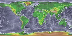
| Map of the world
during the Last Glacial Maximum. |
Pleistocene
The Pleistocene ( /ˈplaɪs.təˌsiːn, -toʊ-/ PLYSE-tə-seen,
-toh-, often colloquially referred to as the Ice Age)
is the geological epoch that lasted from about 2,580,000
to 11,700 years ago, spanning the world's most recent
period of repeated glaciations. Before a change finally
confirmed in 2009 by the International Union of
Geological Sciences, the cutoff of the Pleistocene and
the preceding Pliocene was regarded as being at 1.806
million years Before Present (BP). Publications from
earlier years may use either definition of the period.
The end of the Pleistocene corresponds with the end of
the last glacial period and also with the end of the
Paleolithic age used in archaeology. The name is a
combination of Ancient Greek πλεῖστος (pleīstos, "most")
and καινός (kainós (latinized as cænus), "new".
At the end of the preceding Pliocene, the previously
isolated North and South American continents were joined
by the Isthmus of Panama, causing a faunal interchange
between the two regions and changing ocean circulation
patterns, with the onset of glaciation in the Northern
Hemisphere occurring around 2.7 million years ago.
During the Early Pleistocene (2.58-0.8 Ma), archaic
humans of the genus Homo originated in Africa and spread
throughout Afro-Eurasia. The end of the Early
Pleistocene is marked by the Mid-Pleistocene Transition,
with the cyclicity of glacial cycles changing from
41,000 year cycles to 100,000 year cycles. The Late
Pleistocene witnessed the spread of modern humans
outside of Africa as well as the extinction of all other
human species. Humans also spread to the Australian
continent and the Americas for the first time,
co-incident with the extinction of most large bodied
animals in these regions.
The aridification and cooling trends of the preceding
Neogene were continued in the Pleistocene. The climate
was strongly variable depending on the glacial cycle,
with the sea levels being up to 120 metres lower than
present at peak glaciation, allowing the connection of
Asia and North America via Beringia and the covering of
most of northern North America by the Laurentide ice
sheet.
Etymology
Charles Lyell introduced the term "Pleistocene" in 1839
to describe strata in Sicily that had at least 70% of
their molluscan fauna still living today. This
distinguished it from the older Pliocene epoch, which
Lyell had originally thought to be the youngest fossil
rock layer. He constructed the name "Pleistocene" ("Most
New" or "Newest") from the Greek πλεῖστος (pleīstos,
"most") and καινός (kainós (latinized as cænus), "new");
this contrasts with the immediately preceding Pliocene
("newer", from πλείων (pleíōn, "more") and kainós) and
the immediately subsequent Holocene ("wholly new" or
"entirely new", from ὅλος (hólos, "whole") and kainós)
epoch, which extends to the present time. |
|
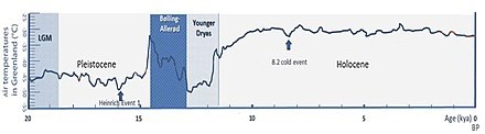 |
| Evolution of
temperature in the Post-Glacial period at the
very end of the Pleistocene, according to
Greenland ice cores. |
Dating
The Pleistocene has been dated from 2.580 million
(±0.005) to 11,650 years BP with the end date expressed
in radiocarbon years as 10,000 carbon-14 years BP. It
covers most of the latest period of repeated glaciation,
up to and including the Younger Dryas cold spell. The
end of the Younger Dryas has been dated to about 9640 BC
(11,654 calendar years BP). The end of the Younger Dryas
is the official start of the current Holocene Epoch.
Although it is considered an epoch, the Holocene is not
significantly different from previous interglacial
intervals within the Pleistocene. In the ICS timescale,
the Pleistocene is divided into four stages or ages, the
Gelasian, Calabrian, Chibanian (previously the
unofficial "Middle Pleistocene"), and Upper Pleistocene
(unofficially the "Tarantian"). In addition to these
international subdivisions, various regional
subdivisions are often used.
In 2009 the International Union of Geological Sciences
(IUGS) confirmed a change in time period for the
Pleistocene, changing the start date from 1.806 to 2.588
million years BP, and accepted the base of the Gelasian
as the base of the Pleistocene, namely the base of the
Monte San Nicola GSSP. The start date has now been
rounded down to 2.580 million years BP. The IUGS has yet
to approve a type section, Global Boundary Stratotype
Section and Point (GSSP), for the upper
Pleistocene/Holocene boundary (i.e. the upper boundary).
The proposed section is the North Greenland Ice Core
Project ice core 75° 06' N 42° 18' W. The lower boundary
of the Pleistocene Series is formally defined
magnetostratigraphically as the base of the Matuyama
(C2r) chronozone, isotopic stage 103. Above this point
there are notable extinctions of the calcareous
nanofossils: Discoaster pentaradiatus and Discoaster
surculus. The Pleistocene covers the recent period of
repeated glaciations.
The name Plio-Pleistocene has, in the past, been used to
mean the last ice age. Formerly, the boundary between
the two epochs was drawn at the time when the
foraminiferal species Hyalinea baltica first appeared in
the marine section at La Castella, Calabria, Italy;
however, the revised definition of the Quaternary, by
pushing back the start date of the Pleistocene to 2.58
Ma, results in the inclusion of all the recent repeated
glaciations within the Pleistocene.
Radiocarbon dating is considered to be inaccurate beyond
around 50,000 years ago. Marine isotope stages (MIS)
derived from Oxygen isotopes are often used for giving
approximate dates.
Deposits
Pleistocene non-marine sediments are found primarily in
fluvial deposits, lakebeds, slope and loess deposits as
well as in the large amounts of material moved about by
glaciers. Less common are cave deposits, travertines and
volcanic deposits (lavas, ashes). Pleistocene marine
deposits are found primarily in shallow marine basins
mostly (but with important exceptions) in areas within a
few tens of kilometers of the modern shoreline. In a few
geologically active areas such as the Southern
California coast, Pleistocene marine deposits may be
found at elevations of several hundred meters. |
|
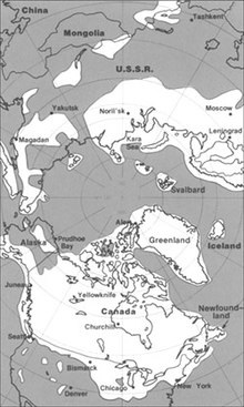 |
| The maximum extent
of glacial ice in the north polar area during
the Pleistocene period. |
Paleogeography
and climate
The modern continents were essentially at their present
positions during the Pleistocene, the plates upon which
they sit probably having moved no more than 100 km
relative to each other since the beginning of the
period. In glacial periods, the sea level would drop by
over 100 metres during peak glaciation, exposing large
areas of present continental shelf as dry land.
According to Mark Lynas (through collected data), the
Pleistocene's overall climate could be characterized as
a continuous El Niño with trade winds in the south
Pacific weakening or heading east, warm air rising near
Peru, warm water spreading from the west Pacific and the
Indian Ocean to the east Pacific, and other El Niño
markers.
Glacial features
Pleistocene climate was marked by repeated glacial
cycles in which continental glaciers pushed to the 40th
parallel in some places. It is estimated that, at
maximum glacial extent, 30% of the Earth's surface was
covered by ice. In addition, a zone of permafrost
stretched southward from the edge of the glacial sheet,
a few hundred kilometres in North America, and several
hundred in Eurasia. The mean annual temperature at the
edge of the ice was −6 °C (21 °F); at the edge of the
permafrost, 0 °C (32 °F).
Each glacial advance tied up huge volumes of water in
continental ice sheets 1,500 to 3,000 metres
(4,900–9,800 ft) thick, resulting in temporary sea-level
drops of 100 metres (300 ft) or more over the entire
surface of the Earth. During interglacial times, such as
at present, drowned coastlines were common, mitigated by
isostatic or other emergent motion of some regions.
The effects of glaciation were global. Antarctica was
ice-bound throughout the Pleistocene as well as the
preceding Pliocene. The Andes were covered in the south
by the Patagonian ice cap. There were glaciers in New
Zealand and Tasmania. The current decaying glaciers of
Mount Kenya, Mount Kilimanjaro, and the Ruwenzori Range
in east and central Africa were larger. Glaciers existed
in the mountains of Ethiopia and to the west in the
Atlas mountains.
In the northern hemisphere, many glaciers fused into
one. The Cordilleran Ice Sheet covered the North
American northwest; the east was covered by the
Laurentide. The Fenno-Scandian ice sheet rested on
northern Europe, including much of Great Britain; the
Alpine ice sheet on the Alps. Scattered domes stretched
across Siberia and the Arctic shelf. The northern seas
were ice-covered.
South of the ice sheets large lakes accumulated because
outlets were blocked and the cooler air slowed
evaporation. When the Laurentide Ice Sheet retreated,
north-central North America was totally covered by Lake
Agassiz. Over a hundred basins, now dry or nearly so,
were overflowing in the North American west. Lake
Bonneville, for example, stood where Great Salt Lake now
does. In Eurasia, large lakes developed as a result of
the runoff from the glaciers. Rivers were larger, had a
more copious flow, and were braided. African lakes were
fuller, apparently from decreased evaporation. Deserts,
on the other hand, were drier and more extensive.
Rainfall was lower because of the decreases in oceanic
and other evaporation.
It has been estimated that during the Pleistocene, the
East Antarctic Ice Sheet thinned by at least 500 meters,
and that thinning since the Last Glacial Maximum is less
than 50 meters and probably started after ca 14 ka. |
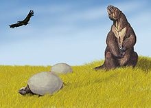 |
| Pleistocene of South
America, including Megatherium and two
Glyptodon. |
Fauna
Both marine and continental faunas were essentially
modern but with many more large land mammals such as
Mammoths, Mastodons, Diprotodon, Smilodon, tiger, lion,
Aurochs, short-faced bears, giant sloths,
Gigantopithecus and others. Isolated landmasses such as
Australia, Madagascar, New Zealand and islands in the
Pacific saw the evolution of large birds and even
reptiles such as the Elephant bird, moa, Haast's eagle,
Quinkana, Megalania and Meiolania.
The severe climatic changes during the Ice Age had major
impacts on the fauna and flora. With each advance of the
ice, large areas of the continents became totally
depopulated, and plants and animals retreating
southwards in front of the advancing glacier faced
tremendous stress. The most severe stress resulted from
drastic climatic changes, reduced living space, and
curtailed food supply. A major extinction event of large
mammals (megafauna), which included mammoths, mastodons,
saber-toothed cats, glyptodons, the woolly rhinoceros,
various giraffids, such as the Sivatherium; ground
sloths, Irish elk, cave bears, Gomphothere, dire wolves,
and short-faced bears, began late in the Pleistocene and
continued into the Holocene. Neanderthals also became
extinct during this period. At the end of the last ice
age, cold-blooded animals, smaller mammals like wood
mice, migratory birds, and swifter animals like
whitetail deer had replaced the megafauna and migrated
north. Late Pleistocene bighorn sheep were more slender
and had longer legs than their descendants today.
Scientists believe that the change in predator fauna
after the late Pleistocene extinctions resulted in a
change of body shape as the species adapted for
increased power rather than speed.
The extinctions hardly affected Africa but were
especially severe in North America where native horses
and camels were wiped out. |
- Asian land mammal ages (ALMA)
include Zhoukoudianian, Nihewanian, and Yushean.
- European land mammal ages (ELMA)
include Gelasian (2.5–1.8 Ma).
- North American land mammal ages
(NALMA) include Blancan (4.75–1.8), Irvingtonian
(1.8–0.24) and Rancholabrean (0.24–0.01) in millions of
years. The Blancan extends significantly back into the
Pliocene.
- South American land mammal ages
(SALMA) include Uquian (2.5–1.5), Ensenadan (1.5–0.3)
and Lujanian (0.3–0.01) in millions of years. The Uquian
previously extended significantly back into the
Pliocene, although the new definition places it entirely
within the Pleistocene.
|
|
In July 2018, a team of Russian scientists in collaboration
with Princeton University announced that they had brought
two female nematodes frozen in permafrost, from around
42,000 years ago, back to life. The two nematodes, at the
time, were the oldest confirmed living animals on the
planet. |
|