 |
| Map of North
America, from 1621. |
Name
The Americas are usually accepted as having been named
after the Italian explorer Amerigo Vespucci by the
German cartographers Martin Waldseemüller and Matthias
Ringmann. Vespucci, who explored South America between
1497 and 1502, was the first European to suggest that
the Americas were not the East Indies, but a different
landmass previously unknown by Europeans. In 1507,
Waldseemüller produced a world map, in which he placed
the word "America" on the continent of South America, in
the middle of what is today Brazil. He explained the
rationale for the name in the accompanying book
Cosmographiae Introductio:
... ab Americo inventore ... quasi Americi terram sive
Americam (from Americus the discoverer ... as if it were
the land of Americus, thus America).
For Waldseemüller, no one should object to the naming of
the land after its discoverer. He used the Latinized
version of Vespucci's name (Americus Vespucius), but in
its feminine form "America", following the examples of "Europa",
"Asia" and "Africa".
Later, other mapmakers extended the name America to the
northern continent, In 1538, Gerard Mercator used
America on his map of the world for all the Western
Hemisphere.
Some argue that the convention is to use the surname for
naming discoveries except in the case of royalty and so
a derivation from "Amerigo Vespucci" could be
problematic. Ricardo Palma (1949) proposed a derivation
from the "Amerrique" mountains of Central America—Vespucci
was the first to discover South America and the
Amerrique mountains of Central America, which connected
his discoveries to those of Christopher Columbus.
Alfred E. Hudd proposed a theory in 1908 that the
continents are named after a Welsh merchant named
Richard Amerike from Bristol, who is believed to have
financed John Cabot's voyage of discovery from England
to Newfoundland in 1497. A minutely explored belief that
has been advanced is that America was named for a
Spanish sailor bearing the ancient Visigothic name of 'Amairick'.
Another is that the name is rooted in a Native American
language. |
 |
| Map of populous
North America showing physical, political and
population characteristics as per 2018. |
Extent
The term North America maintains various definitions in
accordance with location and context. In Canadian
English, North America may be used to refer to the
United States and Canada together. Alternatively, usage
sometimes includes Greenland and Mexico (as in the North
American Free Trade Agreement), as well as offshore
islands. The UN geoscheme for "North America" separates
Mexico from the United States and Canada, placing it
instead within its designated "Central America" region,
while also treating the islands of the Caribbean
separately from the US/Canada definition—the UN's "North
America" definition still includes the Canadian Arctic
Archipelago and Greenland together with the US/Canada
continental definition, with both insular entities being
tectonically on the North American plate.
In France, Italy, Portugal, Spain, Romania, Greece, and
the countries of Latin America, the cognates of North
America usually designate a subcontinent of the Americas
comprising Canada, the United States, and Mexico, and
often Greenland, Saint Pierre et Miquelon, and Bermuda.
North America has been historically referred to by other
names. Spanish North America (New Spain) was often
referred to as Northern America, and this was the first
official name given to Mexico.
Regions
Geographically the North American continent has many
regions and subregions. These include cultural,
economic, and geographic regions. Economic regions
included those formed by trade blocs, such as the North
American Trade Agreement bloc and Central American Trade
Agreement. Linguistically and culturally, the continent
could be divided into Anglo-America and Latin America.
Anglo-America includes most of Northern America, Belize,
and Caribbean islands with English-speaking populations
(though sub-national entities, such as Louisiana and
Quebec, are Francophone in composition).
The southern North American continent is composed of two
regions. These are Central America and the Caribbean.
The north of the continent maintains recognized regions
as well. In contrast to the common definition of "North
America", that which encompasses the whole continent,
the term "North America" is also used to refer to
Canada, Mexico, the United States, and Greenland.
The term Northern America refers to the northern-most
countries and territories of North America, Canada, the
United States, Greenland, Bermuda, and St. Pierre and
Miquelon. Although rarely used, the term Middle
America—not to be confused with the Midwestern United
States—groups the regions of Central America, the
Caribbean, and Mexico.
The largest countries of the continent, Canada and the
United States, also contain well-defined and recognized
regions. In the case of Canada these are the British
Columbia Coast, Canadian Prairies, Central Canada,
Atlantic Canada, and Northern Canada. These regions also
contain many subregions. In the case of the United
States – and in accordance with the US Census Bureau
definitions – these regions are: New England,
Mid-Atlantic, East North Central States, West North
Central States, South Atlantic States, East South
Central States, West South Central States, Mountain
States, and Pacific States. Regions shared between both
nations included the Great Lakes Region. Megalopolises
have also formed between both nations in the case of the
Pacific Northwest and the Great Lakes Megaregion. |
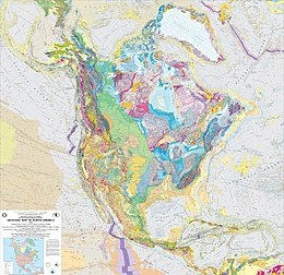 |
| Geologic Map of
North America published by USGS. |
History
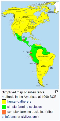
Geologic history
Laurentia is an ancient craton which forms the geologic
core of North America; it formed between 1.5 and 1.0
billion years ago during the Proterozoic eon. The
Canadian Shield is the largest exposure of this craton.
From the Late Paleozoic to Early Mesozoic eras, North
America was joined with the other modern-day continents
as part of the supercontinent Pangaea, with Eurasia to
its east. One of the results of the formation of Pangaea
was the Appalachian Mountains, which formed some 480
million years ago, making it among the oldest mountain
ranges in the world. When Pangaea began to rift around
200 million years ago, North America became part of
Laurasia, before it separated from Eurasia as its own
continent during the mid-Cretaceous period. The Rockies
and other western mountain ranges began forming around
this time from a period of mountain building called the
Laramide orogeny, between 80 and 55 million years ago.
The formation of the Isthmus of Panama that connected
the continent to South America arguably occurred
approximately 12 to 15 million years ago, and the Great
Lakes (as well as many other northern freshwater lakes
and rivers) were carved by receding glaciers about
10,000 years ago.
North America is the source of much of what humanity
knows about geologic time periods. The geographic area
that would later become the United States has been the
source of more varieties of dinosaurs than any other
modern country. According to paleontologist Peter
Dodson, this is primarily due to stratigraphy, climate
and geography, human resources, and history. Much of the
Mesozoic Era is represented by exposed outcrops in the
many arid regions of the continent. The most significant
Late Jurassic dinosaur-bearing fossil deposit in North
America is the Morrison Formation of the western United
States. |
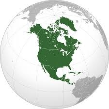
Pre-Columbian
The indigenous peoples of North America have many
creation myths by which they assert that they have been
present on the land since its creation. The specifics of
Paleo-Indian migration to and throughout the Americas,
including the exact dates and routes traveled, are
subject to ongoing research and discussion. The
traditional theory has been that these early migrants
moved into the Beringia land bridge between eastern
Siberia and present-day Alaska around 25,000 to 11,000
years ago. The few agreements achieved to date are the
origin from Central Asia, with widespread habitation of
the Americas during the end of the last glacial period,
or more specifically what is known as the late glacial
maximum, around 13,000 years before present. Some
genetic research indicated secondary waves of migration
occurred after the initial Paleo-Indian colonization,
but prior to modern Inuit, Inupiat and Yupik expansions.
Before contact with Europeans, the natives of North
America were divided into many different polities, from
small bands of a few families to large empires. They
lived in several "culture areas", which roughly
correspond to geographic and biological zones and give a
good indication of the main lifeway or occupation of the
people who lived there (e.g., the bison hunters of the
Great Plains, or the farmers of Mesoamerica). Native
groups can also be classified by their language family
(e.g., Athapascan or Uto-Aztecan). Peoples with similar
languages did not always share the same material
culture, nor were they always allies. Anthropologists
think that the Inuit people of the high Arctic came to
North America much later than other native groups, as
evidenced by the disappearance of Dorset culture
artifacts from the archaeological record, and their
replacement by the Thule people.
During the thousands of years of native habitation on
the continent, cultures changed and shifted. One of the
oldest cultures yet found is the Clovis culture of
modern New Mexico. Later cultures include the
Mississippian culture and related Mound building
cultures, found in the Mississippi river valley and the
Pueblo culture of what is now the Four Corners. The more
southern cultural groups of North America were
responsible for the domestication of many common crops
now used around the world, such as tomatoes and squash.
Perhaps most importantly they domesticated one of the
world's major staples, maize (corn).
The earliest verifiable instance of pre-Columbian
trans-oceanic contact by any European culture with the
landmasses that geologically constitute the "mainland"
of modern North America has been dated to the end of the
10th century CE - this site, situated at the
northernmost extent of the island named Newfoundland, is
known as L'Anse aux Meadows, where unmistakable evidence
of Norse settlement was uncovered in the early 1960s.
As a result of the development of agriculture in the
south, many important cultural advances were made there.
For example, the Maya civilization developed a writing
system, built huge pyramids and temples, had a complex
calendar, and developed the concept of zero around 400
CE, a few hundred years after the Mesopotamians. The
Mayan culture was still present in southern Mexico and
Guatemala when the Spanish explorers arrived, but
political dominance in the area had shifted to the Aztec
Empire whose capital city Tenochtitlan was located
further north in the Valley of Mexico. The Aztecs were
conquered in 1521 by Hernán Cortés. |
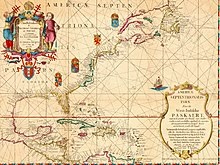
 |
| Map of North America
in 1702 showing forts, towns and (in solid
colors) areas occupied by European settlements. |
Colonial period
During the Age of Discovery, Europeans explored and
staked claims to various parts of North America. Upon
their arrival in the "New World", the Native American
population declined substantially, because of violent
conflicts with the invaders and the introduction of
European diseases to which the Native Americans lacked
immunity. Native culture changed drastically and their
affiliation with political and cultural groups also
changed. Several linguistic groups died out, and others
changed quite quickly. The names and cultures that
Europeans recorded were not necessarily the same as the
names they had used a few generations before, or the
ones in use today.
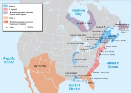
Britain, Spain, and France took over extensive
territories in North America - and fought over them. In
the late 18th century and beginning of the 19th,
independence movements that sprung up across the
continent, led to the creation of the modern countries
in the area. The 13 British colonies on the North
Atlantic coast declared independence in 1776, becoming
the United States of America. Canada was formed from the
unification of northern territories controlled by
Britain and France. New Spain, a territory that
stretched from modern-day southern US to Central
America, declared independence in 1810, becoming the
First Mexican Empire. In 1823 the former Captaincy
General of Guatemala, then part of the Mexican Empire,
became the first independent state in Central America,
officially changing its name to the United Provinces of
Central America. |
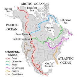 |
| Principal
hydrological divides of Canada, the United
States and Mexico. |
Geography
North America occupies the northern portion of the
landmass generally referred to as the New World, the
Western Hemisphere, the Americas, or simply America
(which, less commonly, is considered by some as a single
continent with North America a subcontinent). North
America's only land connection to South America is at
the Isthmus of Panama. The continent is delimited on the
southeast by most geographers at the Darién watershed
along the Colombia-Panama border, placing all of Panama
within North America. Alternatively, some geologists
physiographically locate its southern limit at the
Isthmus of Tehuantepec, Mexico, with Central America
extending southeastward to South America from this
point. The Caribbean islands, or West Indies, are
considered part of North America. The continental
coastline is long and irregular. The Gulf of Mexico is
the largest body of water indenting the continent,
followed by Hudson Bay. Others include the Gulf of Saint
Lawrence and the Gulf of California.
Before the Central American isthmus formed, the region
had been underwater. The islands of the West Indies
delineate a submerged former land bridge, which had
connected North and South America via what are now
Florida and Venezuela.
There are numerous islands off the continent's coasts;
principally, the Arctic Archipelago, the Bahamas, Turks
& Caicos, the Greater and Lesser Antilles, the Aleutian
Islands (some of which are in the Eastern Hemisphere
proper), the Alexander Archipelago, the many thousand
islands of the British Columbia Coast, and Newfoundland.
Greenland, a self-governing Danish island, and the
world's largest, is on the same tectonic plate (the
North American Plate) and is part of North America
geographically. In a geologic sense, Bermuda is not part
of the Americas, but an oceanic island which was formed
on the fissure of the Mid-Atlantic Ridge over 100
million years ago. The nearest landmass to it is Cape
Hatteras, North Carolina. However, Bermuda is often
thought of as part of North America, especially given
its historical, political and cultural ties to Virginia
and other parts of the continent.
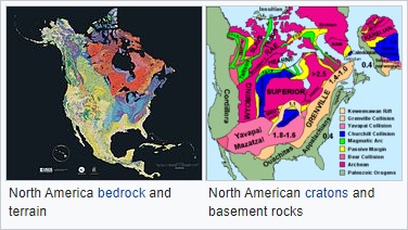
The vast majority of North America is on the North
American Plate. Parts of western Mexico, including Baja
California, and of California, including the cities of
San Diego, Los Angeles, and Santa Cruz, lie on the
eastern edge of the Pacific Plate, with the two plates
meeting along the San Andreas fault. The southernmost
portion of the continent and much of the West Indies lie
on the Caribbean Plate, whereas the Juan de Fuca and
Cocos plates border the North American Plate on its
western frontier.
The continent can be divided into four great regions
(each of which contains many subregions): the Great
Plains stretching from the Gulf of Mexico to the
Canadian Arctic; the geologically young, mountainous
west, including the Rocky Mountains, the Great Basin,
California and Alaska; the raised but relatively flat
plateau of the Canadian Shield in the northeast; and the
varied eastern region, which includes the Appalachian
Mountains, the coastal plain along the Atlantic
seaboard, and the Florida peninsula. Mexico, with its
long plateaus and cordilleras, falls largely in the
western region, although the eastern coastal plain does
extend south along the Gulf.
The western mountains are split in the middle into the
main range of the Rockies and the coast ranges in
California, Oregon, Washington, and British Columbia,
with the Great Basin—a lower area containing smaller
ranges and low-lying deserts—in between. The highest
peak is Denali in Alaska.
The United States Geographical Survey (USGS) states that
the geographic center of North America is "6 miles [10
km] west of Balta, Pierce County, North Dakota" at about
48°10′N 100°10′W / 48.167°N 100.167°W, about 24
kilometres (15 mi) from Rugby, North Dakota. The USGS
further states that "No marked or monumented point has
been established by any government agency as the
geographic center of either the 50 States, the
conterminous United States, or the North American
continent." Nonetheless, there is a 4.6-metre (15 ft)
field stone obelisk in Rugby claiming to mark the
center. The North American continental pole of
inaccessibility is located 1,650 km (1,030 mi) from the
nearest coastline, between Allen and Kyle, South Dakota
at 43°22′N 101°58′W / 43.36°N 101.97°W. |
Geology
Canadian geology
Geologically, Canada is one of the oldest regions in the
world, with more than half of the region consisting of
precambrian rocks that have been above sea level since
the beginning of the Palaeozoic era. Canada's mineral
resources are diverse and extensive. Across the Canadian
Shield and in the north there are large iron, nickel,
zinc, copper, gold, lead, molybdenum, and uranium
reserves. Large diamond concentrations have been
recently developed in the Arctic, making Canada one of
the world's largest producers. Throughout the Shield
there are many mining towns extracting these minerals.
The largest, and best known, is Sudbury, Ontario.
Sudbury is an exception to the normal process of forming
minerals in the Shield since there is significant
evidence that the Sudbury Basin is an ancient meteorite
impact crater. The nearby, but less known Temagami
Magnetic Anomaly has striking similarities to the
Sudbury Basin. Its magnetic anomalies are very similar
to the Sudbury Basin, and so it could be a second
metal-rich impact crater. The Shield is also covered by
vast boreal forests that support an important logging
industry.
United States geology
The lower 48 US states can be divided into roughly five
physiographic provinces: |
- The American cordillera.
- The Canadian Shield. Northern
portion of the upper midwestern United States.
- The stable platform.
- The coastal plain.
- The Appalachian orogenic belt.
|
|
The geology of Alaska is typical of that of the cordillera,
while the major islands of Hawaii consist of Neogene
volcanoes erupted over a hot spot. |
Central American geology
Central America is geologically active with volcanic
eruptions and earthquakes occurring from time to time. In
1976 Guatemala was hit by a major earthquake, killing 23,000
people; Managua, the capital of Nicaragua, was devastated by
earthquakes in 1931 and 1972, the last one killing about
5,000 people; three earthquakes devastated El Salvador, one
in 1986 and two in 2001; one earthquake devastated northern
and central Costa Rica in 2009, killing at least 34 people;
in Honduras a powerful earthquake killed seven people in
2009.
Volcanic eruptions are common in the region. In 1968 the
Arenal Volcano, in Costa Rica, erupted and killed 87 people.
Fertile soils from weathered volcanic lavas have made it
possible to sustain dense populations in the agriculturally
productive highland areas.
Central America has many mountain ranges; the longest are
the Sierra Madre de Chiapas, the Cordillera Isabelia, and
the Cordillera de Talamanca. Between the mountain ranges lie
fertile valleys that are suitable for the people; in fact,
most of the population of Honduras, Costa Rica, and
Guatemala live in valleys. Valleys are also suitable for the
production of coffee, beans, and other crops. |
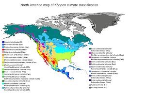 |
| North America map of
Köppen climate classification. |
Climate
North America is a very large continent which surpasses the
Arctic Circle, and the Tropic of Cancer. Greenland, along
with the Canadian shield, is tundra with average
temperatures ranging from between 10 to 20 °C (50 to 68 °F),
but central Greenland is composed of a very large ice sheet.
This tundra radiates throughout Canada, but its border ends
near the Rocky Mountains (but still contains Alaska) and at
the end of the Canadian Shield, near the Great Lakes.
Climate west of the Cascades is described as being a
temperate weather with average precipitation 20 inches (510
mm). Climate in coastal California is described to be
Mediterranean, with average temperatures in cities like San
Francisco ranging from between 57 to 70 °F (14 to 21 °C)
over the course of the year.
Stretching from the East Coast to eastern North Dakota, and
stretching down to Kansas, is the continental-humid climate
featuring hard seasons, with a large amount of annual
precipitation, with places like New York City averaging 50
inches (1,300 mm). Starting at the southern border of the
continental-humid climate and stretching to the Gulf of
Mexico (whilst encompassing the eastern half of Texas) is
the subtropical climate. This area has the wettest cities in
the contiguous U.S. with annual precipitation reaching 67
inches (1,700 mm) in Mobile, Alabama. Stretching from the
borders of the continental humid and subtropical climates,
and going west to the Cascades Sierra Nevada, south to the
southern tip of durango, north to the border with tundra
climate, the steppe/desert climate is the driest climate in
the U.S. |
|
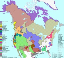 |
| Native languages of
the US, Canada and Greenland. |
Demographics
Economically, Canada and the United States are the
wealthiest and most developed nations in the continent,
followed by Mexico, a newly industrialized country. The
countries of Central America and the Caribbean are at
various levels of economic and human development. For
example, small Caribbean island-nations, such as
Barbados, Trinidad and Tobago, and Antigua and Barbuda,
have a higher GDP (PPP) per capita than Mexico due to
their smaller populations. Panama and Costa Rica have a
significantly higher Human Development Index and GDP
than the rest of the Central American nations.
Additionally, despite Greenland's vast resources in oil
and minerals, much of them remain untapped, and the
island is economically dependent on fishing, tourism,
and subsidies from Denmark. Nevertheless, the island is
highly developed.
Demographically, North America is ethnically diverse.
Its three main groups are Caucasians, Mestizos and
Blacks.
Languages
The dominant languages in North America are English,
Spanish, and French. Danish is prevalent in Greenland
alongside Greenlandic, and Dutch is spoken side by side
local languages in the Dutch Caribbean. The term
Anglo-America is used to refer to the anglophone
countries of the Americas: namely Canada (where English
and French are co-official) and the United States, but
also sometimes Belize and parts of the tropics,
especially the Commonwealth Caribbean. Latin America
refers to the other areas of the Americas (generally
south of the United States) where the Romance languages,
derived from Latin, of Spanish and Portuguese (but
French speaking countries are not usually included)
predominate: the other republics of Central America (but
not always Belize), part of the Caribbean (not the
Dutch-, English-, or French-speaking areas), Mexico, and
most of South America (except Guyana, Suriname, French
Guiana (France), and the Falkland Islands (UK)).
The French language has historically played a
significant role in North America and now retains a
distinctive presence in some regions. Canada is
officially bilingual. French is the official language of
the Province of Quebec, where 95% of the people speak it
as either their first or second language, and it is
co-official with English in the Province of New
Brunswick. Other French-speaking locales include the
Province of Ontario (the official language is English,
but there are an estimated 600,000 Franco-Ontarians),
the Province of Manitoba (co-official as de jure with
English), the French West Indies and Saint-Pierre et
Miquelon, as well as the US state of Louisiana, where
French is also an official language. Haiti is included
with this group based on historical association but
Haitians speak both Creole and French. Similarly, French
and French Antillean Creole is spoken in Saint Lucia and
the Commonwealth of Dominica alongside English. |
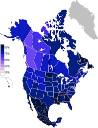 |
| Religious Belief in
North America, according to 2010–2012 data. |
Religions
Christianity is the largest religion in the United
States, Canada and Mexico according to a 2012 Pew
Research Center survey, 77.4% of the population
considered themselves Christians. Christianity also is
the predominant religion in the 23 dependent territories
in North America. The United States has the largest
Christian population in the world, with nearly 247
million Christians (70%), although other countries have
higher percentages of Christians among their
populations. Mexico has the world's second largest
number of Catholics, surpassed only by Brazil. A 2015
study estimates about 493,000 Christian believers from a
Muslim background in North America, most of them
belonging to some form of Protestantism.
According to the same study religiously unaffiliated
(include agnostic and atheist) make up about 17.1% of
the population of Canada and the United States. No
religion make up about 22.8% of the United States
population, and 23.9% of Canada total population.
Canada, the United States and Mexico host communities of
both Jews (6 million or about 1.8%), Buddhists (3.8
million or 1.1%) and Muslims (3.4 million or 1.0%). The
biggest number of Jewish individuals can be found in the
United States (5.4 million), Canada (375,000) and Mexico
(67,476). The United States host the largest Muslim
population in North America with 2.7 million or 0.9%,
While Canada host about one million Muslim or 3.2% of
the population. While in Mexico there were 3,700 Muslims
in the country. In 2012, U-T San Diego estimated U.S.
practitioners of Buddhism at 1.2 million people, of whom
40% are living in Southern California.
The predominant religion in Central America is
Christianity (95.6%). Beginning with the Spanish
colonization of Central America in the 16th century,
Roman Catholicism became the most popular religion in
the region until the first half of the 20th century.
Since the 1960s, there has been an increase in other
Christian groups, particularly Protestantism, as well as
other religious organizations, and individuals
identifying themselves as having no religion. Also
Christianity is the predominant religion in the
Caribbean (84.7%). Other religious groups in the region
are Hinduism, Islam, Rastafari (in Jamaica), and
Afro-American religions such as Santería and Vodou. |
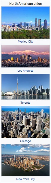
Populace
The most populous country in North America is the United
States with 318.4 million persons. The second largest
country is Mexico with a population of 112,322,757.
Canada is the third most populous country with
32,623,490. The majority of Caribbean island-nations
have national populations under a million, though Cuba,
Dominican Republic, Haiti, Puerto Rico (a territory of
the United States), Jamaica, and Trinidad and Tobago
each have populations higher than a million. Despite
Greenland's massive size (2,166,000 km² or 836,297 mi²),
it has the world's lowest population density at 0.03
pop./km² (0.08 pop./mi²) for a small population of
55,984.
While the United States, Canada, and Mexico maintain the
largest populations, large city populations are not
restricted to those nations. There are also large cities
in the Caribbean. The largest cities in North America,
by far, are Mexico City and New York. These cities are
the only cities on the continent to exceed eight
million, and two of three in the Americas. Next in size
are Los Angeles, Toronto, Chicago, Havana, Santo
Domingo, and Montreal. Cities in the sunbelt regions of
the United States, such as those in Southern California
and Houston, Phoenix, Miami, Atlanta, and Las Vegas, are
experiencing rapid growth. These causes included warm
temperatures, retirement of Baby Boomers, large
industry, and the influx of immigrants. Cities near the
United States border, particularly in Mexico, are also
experiencing large amounts of growth. Most notable is
Tijuana, a city bordering San Diego that receives
immigrants from all over Latin America and parts of
Europe and Asia. Yet as cities grow in these warmer
regions of North America, they are increasingly forced
to deal with the major issue of water shortages.
Eight of the top ten metropolitan areas are located in
the United States. These metropolitan areas all have a
population of above 5.5 million and include the New York
City metropolitan area, Los Angeles metropolitan area,
Chicago metropolitan area, and the Dallas–Fort Worth
metroplex. Whilst the majority of the largest
metropolitan areas are within the United States, Mexico
is host to the largest metropolitan area by population
in North America: Greater Mexico City. Canada also
breaks into the top ten largest metropolitan areas with
the Toronto metropolitan area having six million people.
The proximity of cities to each other on the
Canada–United States border and Mexico–United States
border has led to the rise of international metropolitan
areas. These urban agglomerations are observed at their
largest and most productive in Detroit–Windsor and San
Diego–Tijuana and experience large commercial, economic,
and cultural activity. The metropolitan areas are
responsible for millions of dollars of trade dependent
on international freight. In Detroit-Windsor the Border
Transportation Partnership study in 2004 concluded US$13
billion was dependent on the Detroit–Windsor
international border crossing while in San Diego-Tijuana
freight at the Otay Mesa Port of Entry was valued at
US$20 billion.
North America has also been witness to the growth of
megapolitan areas. In the United States exists eleven
megaregions that transcend international borders and
comprise Canadian and Mexican metropolitan regions.
These are the Arizona Sun Corridor, Cascadia, Florida,
Front Range, Great Lakes Megaregion, Gulf Coast
Megaregion, Northeast, Northern California, Piedmont
Atlantic, Southern California, and the Texas Triangle.
Canada and Mexico are also the home of megaregions.
These include the Quebec City – Windsor Corridor, Golden
Horseshoe – both of which are considered part of the
Great Lakes Megaregion – and megalopolis of Central
Mexico. Traditionally the largest megaregion has been
considered the Boston-Washington, D.C. Corridor, or the
Northeast, as the region is one massive contiguous area.
Yet megaregion criterion have allowed the Great Lakes
Megalopolis to maintain status as the most populated
region, being home to 53,768,125 people in 2000. |
|